The Challenge of Mount Rainier
written by Scott Kranz | Outdoor Adventure, Mountaineering
Even before moving from Minnesota to Seattle in the summer of 2013, I wanted to climb Mount Rainier. At 14,410 feet, Rainier is the highest peak in Washington State and the most prominent and glaciated mountain in the contiguous United States. While millions of people visit Mount Rainier National Park each year and stare up at the massive volcanic structure of rock, snow, and ice, I wanted to join the significantly smaller number of people who attempt to reach its summit.
After immersing myself in snow camping, mountaineering, and climbing over the last year, I finally decided to act on this dream. My good friend Casey Sullivan (@caseys3), a seasoned climber and former mountain rescuer, and I decided to try an early-season summit as an unguided two-person rope team.
While thousands of climbers have successfully reached the summit, there is no doubt that climbing Mount Rainier is exceedingly strenuous and potentially deadly, warranting months of preparation for most climbers. More than a dozen routes lead to the top, and each requires ropes and crampons - and of course the skill and experience to travel safely across steep, glaciated terrain.
Following months of planning and conditioning, and after analyzing snow conditions and weather in the week leading up to our trip, we packed up all of our gear and headed out.
In light of the early-season snow conditions and forecasted weather window, we decided to take the popular Disappointment Cleaver route. This route, which climbers commonly refer to as the "DC," starts at 5400 feet above sea level at Paradise, Washington.
Upon reaching Paradise, we registered for climbing permits at the ranger station and then started snowshoeing up to Camp Muir situated at 10,188 feet. Camp Muir, named after the naturalist and author John Muir, is a refuge with shelters and a common "base camp" for climbers.
The first leg of the trip up to Camp Muir left me exhausted. The combination of the 4700 feet of elevation gain, several hours of exposure to the direct sun, and the weight of my 45-pound pack on my shoulders zapped my energy. Frankly, I became worried about whether I had what it would take to reach the summit the following morning.
When we finally reached Camp Muir (10,188 feet elevation) at 6:30 p.m., I celebrated by ripping off my backpack, inhaling a king-size candy bar, and slugging a liter of water. We were welcomed by several other climbing parties, several of which were similarly going to try the "DC."
At camp, we made final preparations for our climb by hydrating, eating, and melting snow to refill all of our water bottles. We also organized our climbing gear so that we'd be ready to go in the morning. Meanwhile, the sun set on the opposite side of the mountain and faint hues of orange and yellow lingered in the sky to the east and south.
After melting enough snow and setting out all of our climbing gear and rope system, it was already 10 p.m. We headed off to bed to try to get some sleep before our 1 a.m. "alpine start."
Despite my exhaustion, I did not sleep well. After about 45 minutes of total sleep, our 1 a.m. alarm sounded. Although tired and confused, the adrenaline was running high knowing that we would soon be pushing for the summit. At that point, in light of my struggle up to Camp Muir, I did not know whether the summit was within my reach.
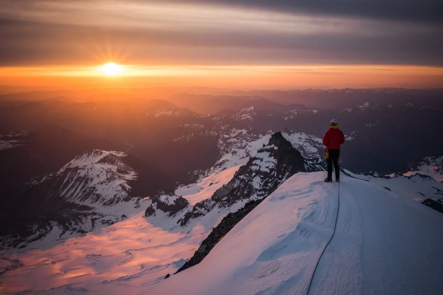
Nonetheless, we got ready, roped up, and started the long trek at 1:45 a.m. From Camp Muir, we traveled by headlamp over the Cowlitz and Ingraham glaciers, navigating around several crevasses big enough to swallow up a house. By 3:30 a.m., we reached the southern base of Disappointment Cleaver. We climbed up the Cleaver, one of the steepest sections of the climb, without the aid of any fixed ropes, a luxury that other climbers would enjoy later in the season. By the time we reached the top of the Cleaver, the sun was peeking out from the northeast horizon, painting the sky with beautiful orange, yellow, and pink colors.
From the top of the Cleaver, we headed east and then traversed north to the Emmons Glacier, where we would make the final steep ascent to the summit. On our way, we navigated through several crevasse fields.
After successfully navigating around numerous crevasses and reaching the Emmons Glacier, the remainder of the route to the summit went straight up. It was grueling, to say the least. At one point, I turned around and looked to the east to see a fellow rope team behind us and Little Tahoma peak.
After reaching the top of the Emmons glacier, we finally reached the Columbia Crest, the crater rim that makes up the summit of Mount Rainier. To reach the summit proper, we dropped into the crater and traveled across to the opposite (west) side. We then ascended another hundred feet or so to tag the official summit. It was 9:15 a.m., eight and a half hours after we left Camp Muir that same morning.
As they say, 'going up the mountain is optional, going down is mandatory.' With that in mind, we enjoyed the summit for a good hour and a half on the summit and decided it was time to descend, knowing that our window of fair weather would soon end.
Especially given the self-doubt I experienced the day before trekking up to Camp Muir, successfully reaching the summit of Mount Rainier at 14,410 feet above sea level was truly an awesome experience. The trip pushed me further physically and mentally than any other trip I've done before, and I learned that anything can be done with enough determination and willpower. I truly believe I'm a stronger and better person after each mountain I climb, and Mount Rainier is no exception.
Join for More (It's Free):
Sign up for my monthly(ish) newsletter where I share field notes, photography tips, outdoor inspiration, early access, and free downloads (like phone wallpapers and photo guides), sent directly to your inbox.
ABOUT THE AUTHOR

Scott Kranz is a full-time outdoor photographer and filmmaker based in Seattle. Born and raised in Minnesota, Scott moved to Washington State in 2013 and first explored the Cascade Range, which sparked a lifelong love of outdoor adventure and photography. Since, he’s come to partner with some of the world’s leading brands and shot on all seven continents.